You are here : Home > Information > Marine Resources > Maps & Charts
Maps & Charts
Updated Monday 29 September 2014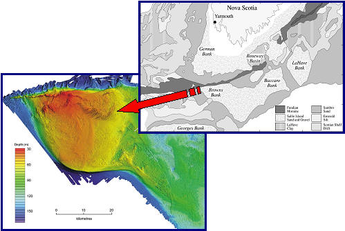
Old + new: linking seabed sediments (above) and multibeam (left) charts to provide habitat maps. Browns Bank off Nova Scotia. Images by courtesy Dr R. A. Pickrill, Bedford Institute of Oceanography.
Australian Hydrographic Service has over 400 paper charts plus electronic and raster charts. An interactive browser identifies charted areas within the Australian region.
Canadian Hydrographic Service offers navigational and bathymetric charts in paper and digital formats, for Canadian waters.
European Centre for Medium-Range Weather Forecasts (ECMWF) generates charts of ocean temperatures, sea level and wind effects primarily for seasonal forecasts: based on computer models.
General Bathymetric Chart of the Ocean (GEBCO) has contoured and 3D bathymetric charts of the worlds ocean. These data are available in digital form on CD-ROM, and as a series of 18, Fifth Edition printed sheets.
Goddard Institute for Space Studies (GISS) has an extensive database of various oceanic and atmospheric parameters including temperature, clouds, precipitation, storm tracks and climate change effects.
Hydrographic and Oceanographic Department, Japan Coast Guard is the focus for navigation, bathymetric and geophysical charts covering the seas around Japan.
Land Information New Zealand is the focus for hydrographic charts in analogue and digital formats for the New Zealand region.
National Geophysical Data Center is the official distribution point for National Ocean Service bathymetric maps, bathymetric/fishing maps, regional maps, geophysical maps, and preliminary maps. NGDC also has an interactive map (ArcIMS) graphic selection page, and previews of maps in pdf format.
Ocean Portal (UNESCO) has a far-reaching list of websites related to charts and hydrography, which can be accessed through the search facility.
Office of Coast Survey (NOAA) produces a comprehensive range of charts for US waters and includes electronic navigation charts, print-on-demand charts plus products and services for Geographic Information Systems (GIS).
United Kingdom Hydrographic Office is a leading provider of charts of the world’s oceans as well as electronic charts (ARCS Navigator) of the world’s major shipping lanes.
Satellite and Other Images of Earth
Coastal Zone Color Scanner images are accessed through a geographically referenced browser.
Earth from Space is a photographic database of NASA Space Shuttle observations. Selected photos give a glimpse of interesting Earth features and processes.
National Oceanographic Data Center carries an extensive catalogue of mapped ocean data derived from satellites and other observational systems.
SeaWiFS Project has collected a broad time-series of satellite images of the ocean, in particular ocean colour which is related to plankton, river sediment, chemistry and current patterns.
Visible Earth is a major catalogue of satellite images covering a wide range of environmental parameters.